
Bicycle trips
Infocentrum, Náměstí Svornosti 2
38211 Český Krumlov
Contact: Infocentrum
Telephone: +420 380 704 622
Fax: +420 380 704 619
E-mail: info@ckrumlov.cz
WWW: www.ckrumlov.cz/info
Location: Český Krumlov
Type: Cycling trails
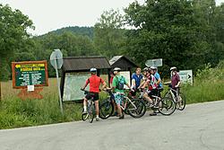
The unspoiled nature surrounding Český Krumlov is ideal for biking. You can make a short, or even a full day trip following well made biking routes. During your biking trip, you will come across many interesting sights, natural wonders and places for refreshment.
Sport Facilities
Travel agency Vltava
Kájovská 62, 381 01 Český Krumlov
Telephone: +420 380 711 988, Fax: +420 380 711 978, E-mail: ckvltava@ckvltava.cz
Ká servis
Pod Sv. Duchem 135, 381 01 Český Krumlov
Telephone: +420 606 609 811, Mobil: +420 606 609 811, E-mail: info@havanahostels.cz
Outdoor Centre Sport-S
Pod Papoščí skálou, 381 01 Český Krumlov
Telephone: +420 777 263 420, Fax: +420 296 301 697
E-mail: outdoor@sport-s.cz
Biking Routes
From Český Krumlov to the Austrian Border (Route no. 12)
Length: 24.8 km. Description: The route starts from Český Krumlov and continues through Spolí to Práčov, from Práčov through the lovely countryside to Zátoň and on to Rožmitál in Šumava. From there the route goes to Hněvanov and through Trojany to Dolní Dvořiště.
Around the Monastery to the Castle (Route no. 12)
Length: 38.9 km. Description: This route starts from Český Krumlov through Srnín to the Zlatá Koruna village, the location of the beautiful Cistercian monastery. From there the route continues to Štěkře, Záluží, Radostice and through Rančice and Boršov nad Vltavou to České Budějovice. From České Budějovice the route goes to Bavorovice and concludes in Hluboká nad Vltavou, dominated by the unique castle.
From Český Krumlov to Lipno Lake (Route no. 1047)
Length: 23.2 km. Description: This route again starts in Český Krumlov and goes toward the Lipno lake. From Český Krumlov the route goes through Kájov, Nový Křenov and Kladenská Rovná to Hořice na Šumavě where after getting though a steep hill it continues to Muckov and concludes in Černá v Pošumaví on the shores of the Lipno lake.
UNESCO Biking Route (Route no. 1169)
Length: 27.3 km. Description: This unique biking route will take you along UNESCO-listed sites. It begins in Český Krumlov and further continues across Nový Dvůr, Chlum and Křemže. From then on through Bohouškovice to Jankov and the route ends in the picturesque UNESCO-listed village of Holašovice.
Cykloroute The Lipno artery
Length : 58,5 km / 36,3 miles
Characteristic : A newly built cycle path on the left-hand shore of the lake connecting the principal tourist resorts of the area.
Route description : Nová Pec (No. 33) - Horní Planá - Hůrka - Černá v Pošumaví - Milná - Frymburk - Slupečná - Lipno nad Vltavou - Loučovice - Čertova stěna - Vyšší Brod.
Adalbert Stifter cykloroute
Length : 65,9 km / 40,9 miles
Characteristic : From the house where Adalbert Stifter was born, through the landscape that he described so vividly in his books, up to the ruin of the castle of Vítkův hrádek and into his beloved Fanny's home.
Route description : Horní Planá (ferry) - Bližší Lhota (blue; No. 1020) - Přední Zvonková (No. 1033) - Zadní Zvonková (border crossing) - Kanalstraße in Austria - Ježová (border crossing) - Koranda (red; č. 1019) - Rozcestí u Janovy cesty (No. 1033) - Svatý Tomáš - Vítkův kámen (green; No. 1021) - Frýdava (ferry) - Frymburk (č. 33) - Milná - Černá v Pošumaví - Hůrka - Horní Planá
Cykloroute Through the mountain range of Svatý Tomáš
Length : 34,0 km / 21,1 miles
Characteristic : Through the thick woods of the mountain range of Svatý Tomáš, with the ruin of the ancient castle of Vítkův hrádek, and the land of "ghost villages", deserted after WW II. and now dilapidated.
Route description : Přední Výtoň (red; No. 1019) - Spáleniště - Pasečná - Koranda - Rozcestí u Janovy cesty (No. 1033) - Svatý Tomáš - Vítkův Kámen (green; No. 1021) - Mírová cesta - Frýdava (red; No. 1019) - Přední Výtoň.
Cykloroute Through the Vltava river valley
Length : 39,9 km / 24,8 miles
Characteristic : Through the Vltava river valley along the magnificent river bed strewn with huge boulders and passing on the way the well-known nature reserve of Čertova stěna (the Devil's Wall).
Route description : Vyšší Brod (No. 1033) - Mnichovice - Kapličky - Spáleniště (Guglwald border crossing 2km; red; No. 1019) - Přední Výtoň (č. 1033) - Frýdava (ferry; No. 33) - Frymburk - Lipno nad Vltavou - Loučovice - Čertova stěna - Vyšší Brod.
Lipno surroundings and Šumava
32,5 km, medium route, road bicycles
Horní Planá (railway station) + Bližší Lhota (ferry) - Přední Zvonková - Zadní Zvonková (border crossing) - Račín - Kyselov + Dolní Vltavice (ferry) - Bližná - Černá v Pošumaví - Hůrka (railway station) - Horní Planá
22,5 km, medium route
Nová Pec (railway station) - Schwarzenberg Navigational canal - Zadní Zvonková (border crossing) - Přední Zvonková - Horní Planá + Bližší Lhota (ferry) - Nová Pec
31 km, medium route
Vyšší Brod (railway station) - (border crossing) Studánky - Mnichovice - Kapličky - Spáleniště (border crossing Guglwald) - Přední Výtoň - Lipno, dike (railway station) - Loučovice (railway station) - Vyšší Brod
36 km, medium route
Frymburk + Frýdava (ferry) - Přední Výtoň - Spáleniště (border crossing Guglwald) - Pasečná - Rychnůvek - Kyselov (Lake Lipno) - Frymburk
Nové Hrady, Kaplice and river Malše surroundings
24 km, medium route, road bicycles, trekking
0,0 Benešov nad Černou - 4,9 Rychnov u Nových Hradů - 8,9 Horní Stropnice - 11,9 Dobrá Voda - 700 m above sea level - 13,1 Hojná Voda - 794 m above sea level - 14,3 Staré Hutě - 18,3 Černé Údolí - 24,1 Benešov nad Černou
34 km, difficult route, trekking, MTB (mountain bikes)
0,0 Benešov nad Černou - 5,0 Černé Údolí - 11,0 Huťský - 16,6 Janova Huť - 19,5 Pohořský rybník (pond) - 23,3 Pohoří na Šumavě - 23,3 Leopoldov - 27,1 Pohorská Ves - 28,3 Lužnice - 32,0 Kuří - 33,7 Benešov nad Černou
30 km, difficult route, trekking, MTB
0,0 Benešov nad Černou - 1,7 Kuří - 5,4 Lužnice - 6,6 Pohorská Ves - 10,4 Leopoldov - 15,3 Dolní Přibrání - 19,4 Bělá - 22,4 Malonty - 24,5 Meziříčí - 30,3 Benešov nad Černou
27 km, medium route, trekking, road bicycles
0,0 Dolní Dvořiště - railway station - Rybník - 2,9 Rychnov nad Malší - 4,7 U Svatého Kamene - 12,5 Cetviny - 15,5 Tokaniště - 16,3 Janova Ves - 19,5 Tichá - 27,2 Dolní Dvořiště
25 km, medium route, trekking, MTB
0,0 Kaplice - 5,3 Jaroměř - 7,5 Malonty - 9,7 Bukovsko - 14,3 Rychnov nad Malší - 18,5 Louzek - 20,2 Skoronice - 24,7 Kaplice